← The Fife and Drum / October 2018 (Vol 22, No 3)
↗ View this article in the original PDF newsletter
This article will outline British and Canadian strategy, developed in the decade following the War of 1812, to deter and defend against any American invasion of the northern colonies. It is also a story of the Board of Ordnance, little known in Canada but the agency then responsible for Imperial military policy and fortification – including the defence of British North America.
Tremendous cost overruns in defence spending and debates about industrial and economic spin-offs are nothing new. While the scale and repercussions of what became a vast defence program are little remembered today, those parts of it that were built are now among our finest tourist attractions – to Canadians and Americans alike!
The War of 1812 revealed three inherent weaknesses in the Canadian position. First was the geographical vulnerability of Upper Canada: the St. Lawrence River was the lifeline of the province. Along the great river came food, manufactures and, in time of war, troops and materiel. The Americans needed only to choose where to cross, to cut the route, and thereby isolate Upper Canada. Second, there would never be enough regular troops to cover the entire frontier. Finally, the population was too small, especially in Upper Canada, to provide economic support and a strong militia.
For the British, the strategic conditions of war were clear enough. British North America’s population and resources were grossly inferior to those of the United States. On land, the Americans could easily invade and occupy large areas of Canada for short periods of time, but could they capture the strongholds? Their logistics were little better than those of the British and neither found it possible for an army to subsist on the produce of Upper Canada. On the high seas, American privateers, fashioned out of the second largest merchant marine in the world, had successfully raided the British merchant trade with Canada and the West Indies (even while Maritime privateers preyed on American trade). All of this emphasized the importance of communications. Britain had the naval strength to ultimately protect its maritime trade, blockade the enemy and harass his coastal cities. But even Great Britain could not conquer the United States. There was also Britain’s growing trade with America, which it did not want to lose. Since the end of the War of Independence, British policy had balanced political responsibilities to the Canadian colonies with the economic opportunities offered by the neighbouring republic.
The Americans began improving their access to the Great Lakes in 1817 by building the Erie Canal to Buffalo. Side branches to Lake Champlain in 1819 and to Oswego in 1828 shifted the trade and military balance of the region toward the United States. The British, with the world’s mightiest empire, could not abandon their colonies to this upstart nation. What could they do to defend them?
The Smyth Report
An appreciation of the lessons learned in the war – and an outline of what to do about them – was drafted by Lieutenant-Colonel Sir John Harvey and given to the Governor General and Commander of Forces, the Duke of Richmond, in 1819. Lt.-Col. Harvey had distinguished himself at the Battle of Stoney Creek in 1813 and knew well the problems of the campaign.
Operations on the frontier must be defensive and designed to resist, dissipate and defeat an invasion
The Duke of Richmond also had excellent military credentials and was a trusted friend of the Duke of Wellington, who was now the Master General of the Ordnance, responsible for the permanent defences of the Empire.
The Duke of Richmond inspected the provinces personally. He sent his appreciation to Wellington in 1819, generally approving of Harvey’s work. Wellington replied with encouraging comments to Lord Dalhousie, the new Governor General. Little was done.
But a new war scare in 1824 led Wellington to instruct Sir James Carmichael Smyth, his Chief Engineer during the late war and now a major-general, to recommend the fortifications and manpower – and to estimate the cost – needed to put a plan for Canadian defence into effect.
The preliminary Smyth Report was dated September 9, 1825, and followed by a more detailed report in February that projected a total cost of £1,646,218. Wellington approved. “I do not entertain the smallest doubt,” he wrote to Lord Bathurst, Secretary of War and the Colonies, “that if the communications and works proposed…are carried into execution, His majesty’s dominions in North America ought to be, and would be, effectually defended and secured against any attempt to be made upon them hereafter by the United States, however formidable their power.”
Wellington (who became Prime Minister in 1828) and his successors at the Board of Ordnance tried hard for the next 25 years to implement Smyth’s plan despite declining military spending and major budget overruns. Financial trouble at the Ordnance, mainly in the Canadas, led to its complete reorganization within the new War Office in 1848. Expenditures in British North America for barracks, fortifications and communications had by then amounted to £2,769,005, a 68% cost overrun. This was three quarters of the sum spent across the entire Empire!
And there were two further costs: the funds expended by the Colonial Office for roads, canals and legal expenses, including settlements for related land disputes; and those of the Commissariat branch, which provided the food, clothing, interim lodging and transportation for militia and regulars in Canada. This was an additional £100,000 to £150,000 per year.
Wellington knew that the forces given to Canadian defence could not – in a context of growing austerity – be greater than the maximum effort of the previous war: 13,500 troops. Even so, he thought this would be enough to hold up a numerically superior force until reinforcements arrived.
Wellington would not get nearly that many soldiers. Instead of two trained corps of 5,000 men each in the field and a total garrison of 13,500 men in the two Canadas, there were on the eve of the rebellions in 1837 only about 5,000 soldiers in all of British North America. Instead of an organized and trained force of 40,000 militia, there was a vast paper army of nearly 250,000 Sedentary Militia, essentially all the men between 18 and 60 years of age. Although several county battalions were raised and trained hard for more than a year in the wake of the rebellions – and were housed in new barracks at the crumbling Fort York and on Bathurst Street, at Queen – these units were soon stood down. What remained was referred to as the Active Militia, men up to the age of 40 required to muster once a year.
A strategic balance
While implementation advanced slowly as funds permitted, and never came close to Smyth’s entire plan, those fortifications, roads and canals that were built did greatly improve the military potential of the colonies. There was also a consensus on the general strategy.
Operations on the frontier must be defensive and designed to resist, dissipate and defeat an invasion. Forts and posts would hold off or delay the enemy on his principal lines of attack, the defenders falling back if necessary upon the bastions protecting the communications with Britain. The main effort would therefore be the defence of five fortresses: Halifax, Quebec, Montreal, Kingston and Niagara. With regular troops holding these, and with militia harassing their flanks and rear, the Americans would not be able to consolidate their grip on the provinces. The British could not sustain such reinforcements in the spring when ships could once more reach Quebec.

Timing was important. Winter would probably help the Americans because it was shorter for them and prevented reinforcement by the British. But it would also prevent any lengthy siege operations against the planned fortresses. The best chance for the Americans, therefore, would be an attack in late winter or early spring, completing their campaign before British help could arrive.
Communication and reinforcement in British North America relied on water transportation. There was no road to Lower Canada from the Maritimes and the only one between Quebec and Amherstburg (at the west end of Lake Erie) was 700 miles long and most useful in winter. During spring and summer, the British position was much better. The comparative invulnerability of Halifax – by way of a presumed naval superiority and the impracticability of a major land attack through the woodlands of Maine and New Brunswick – ensured British command of the St. Lawrence to Quebec. But no farther.
A more secure line of communication was needed from Montreal to Kingston and the upper lakes. While the British dreamed of arming civilian steamboats to create an ad-hoc navy, the Americans had the same ideas and controlled three quarters of Great Lakes shipping. The Royal Navy eventually conceded that it could not gain naval supremacy upstream of Montreal. This depressing situation for the British was matched by a similar but different situation for the Americans; a situation that, for a time, balanced the vulnerability of the Canadas.
The War of 1812 showed clearly the exposure of American coastal cities to heavy raids by the Royal Navy. Baltimore and New Orleans had escaped destruction, but Washington had not, and Smyth thought New York should share its fate in the next war. This the Americans well knew, and an official report in 1840 reminded them that their great cities also held their main arsenals and that New York and Philadelphia. New York City suggested the probable result of a rain of incendiary shells.
Americans spent vast sums building fortifications along their Atlantic seaboard and the Gulf Coast
As a consequence, the Americans spent vast sums building fortifications along their Atlantic seaboard and the Gulf Coast. The forts were described as “incomplete, unfinished, and unarmed” as of 1837, when all required extensive and costly repairs. Nor were there troops to man them. The US Army boasted only 6,000 regulars in 1821, and only 4,000 by 1835 (and few of them faced north). America’s main strength was in its state militias, whereas Canada’s strength was still in its British regulars.
Executing the plan
In the Maritimes, the budget developed by Smyth generally held. Halifax was the cornerstone of Canadian security and British defence policy in the North Atlantic. The Citadel was to be rebuilt at a cost of £160,000 together with subsidiary forts and batteries intended to protect the naval dockyard. Forts at Annapolis and Windsor would prevent a land-based attack on Halifax from the Bay of Fundy. The tidal port of Saint John was to be protected by a new battery on its approaches.
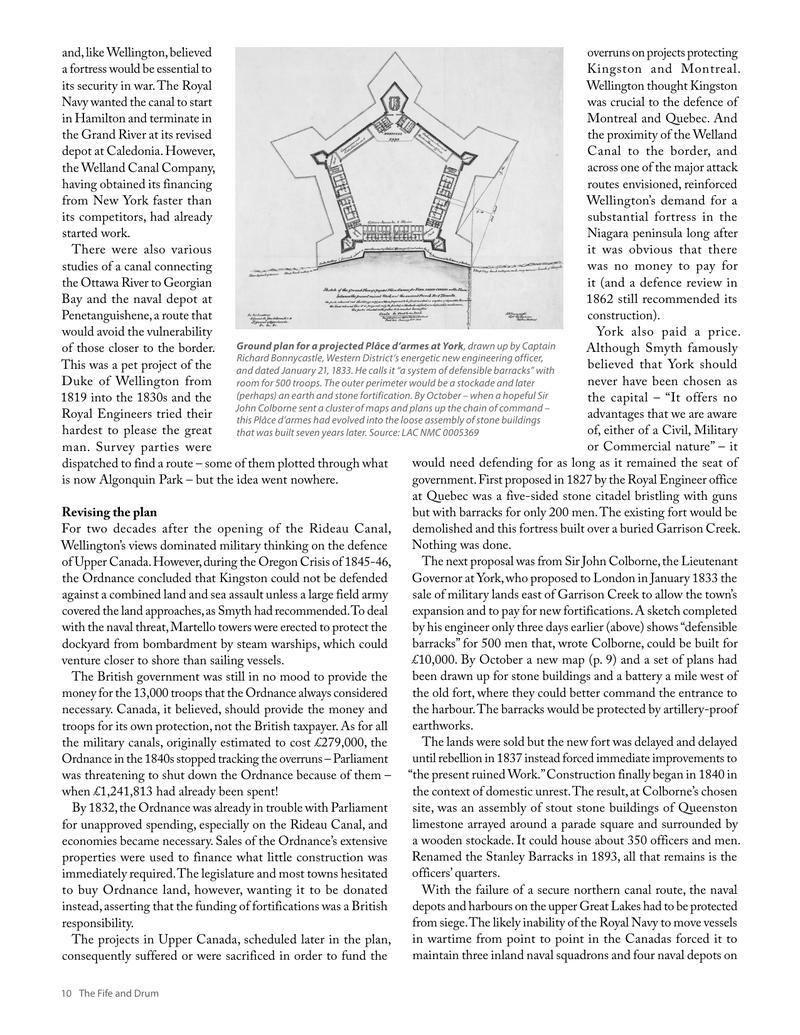
Smyth had recommended two roads to connect the Maritimes with Quebec to allow reinforcements to arrive before the spring breakup in the St. Lawrence. One went from Quebec to Fredericton and Saint John, a distance of 447 miles, by way of Lake Temiscouata and the Saint John River. Large parts of the road existed but it ran along the American border, easily cut in war; £40,000 were nevertheless committed to complete it. New Orleans, sections. By the 1840s the route was in regular use and it is now part of the Trans-Canada Highway. The second route – from Quebec to Moncton to Halifax, more secure but 1000 miles through largely unsurveyed land – was left to provincial legislatures and the march of time.
In Lower Canada, indecision around how to best repel an attack down the Richelieu River is reflected in the cost over-
runs. Against original estimates of £180,000, total costs in the province ballooned to £980,209.
The Quebec Citadel was upgraded to withstand almost any conceivable siege. A planned Montreal citadel, on the other hand, faced no end of opposition. The walls of Montreal had been demolished in 1817 to allow the city to expand. A fortress was originally proposed for Place des Armes, but citizens objected to the demolition of a newly rebuilt city centre. The top of Mount Royal was rejected as too exposed; the plateau there was that the city and the communication route would be in front of the fortress, subject to capture and use in a siege.
Consequently, a plan evolved to build small forts or batteries on the likely landing sites for the upper the island of Montreal. These places were Cascades, Chateauguay, La Prairie, Longueuil and Bout d’Isle.
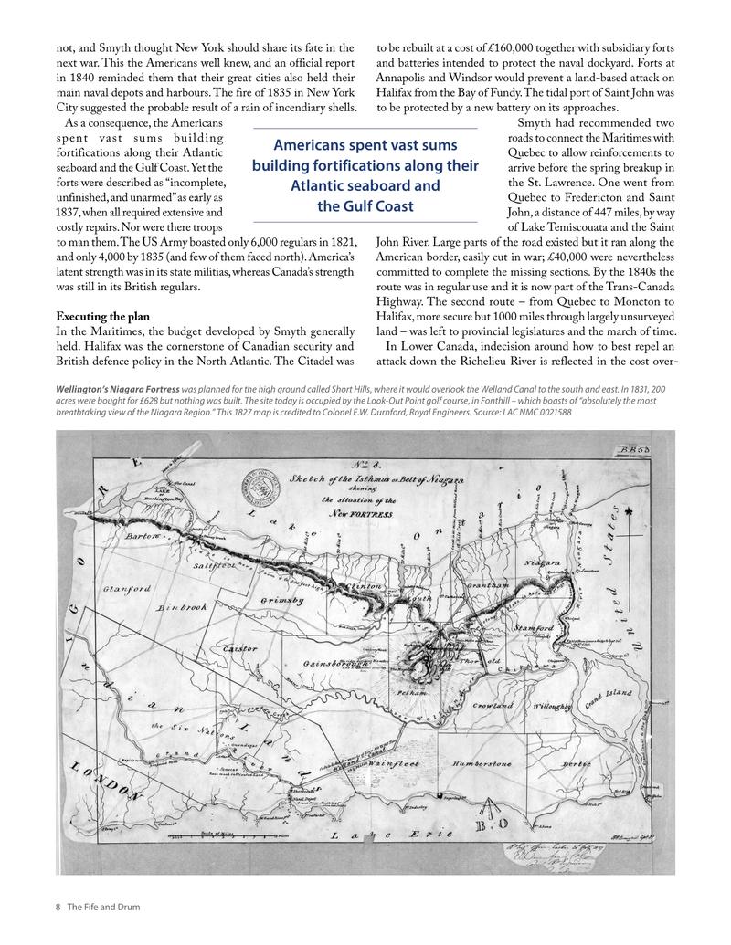
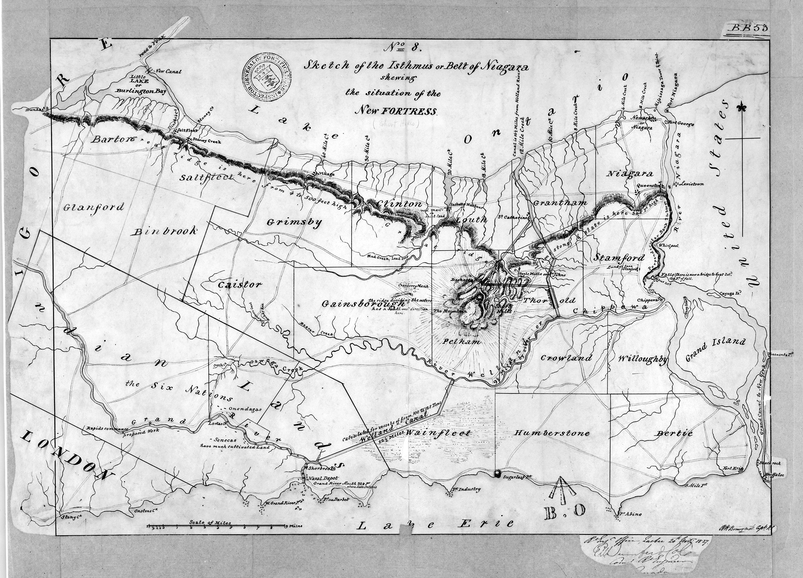
Smyth thought the Welland Canal was too close to the border and, like Wellington, believed a fortress would be essential
The forts along the Richelieu ran six miles north of the border with Fort Lennox at Isle-aux-Noix. Smyth planned minor improvements to the existing works but Wellington insisted on more; by 1829 (and £86,740) Fort Lennox had been rebuilt. The fort at St. Jean, where substantial improvements were also made, protected the place when an attacking force declared whether it was after Montreal or Quebec. The closer portage to Montreal, it was also the terminus of Canada’s first railway in 1836 and it protected the naval depot of the Lake Champlain and Richelieu River flotillas. St. Jean is still an important military base. Chambly, farther downstream, was also to be rebuilt but (thankfully for us) little was done and the French stone fort, built in 1711, was preserved. Some of the money probably went into the Chambly Canal, which by 1840 connected Chambly and St. Jean.
Canals
Before the railways, and when roads were few and muddy, it was lakes, rivers and canals that connected the population centres and military outposts of British North America. Two important aspects of the canal system, however, should be noted.
First was the complexity of its administration, owing to the fact that its various components were governed by different jurisdictions. The Lachine canal was controlled by Montreal, the Vaudreuil lock by a private company, the St. Anne’s lock by Lower Canada, and the Carillon, Chute-à-Blondeau, Grenville and Rideau military canals by the Ordnance from London. The Welland Canal was a private enterprise taken over by Upper Canada in 1841.
Second, the objectives of these canals were as varied as their owners. Building standards and dimensions varied and were never harmonized, and so much of the expenditure and effort was futile. By the mid 1840s, even the new Rideau Canal (finished in 1832) was obsolete for Great Lakes shipping.
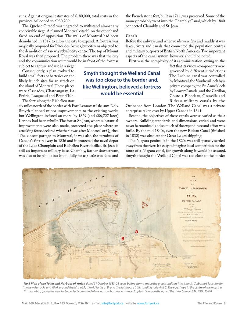
The Niagara peninsula in the 1820s was still sparsely settled away from the river. It’s easy to imagine local competition for the route of a Niagara canal, for growth along it would be assured. Smyth thought the Welland Canal was too close to the border
Original printed pages